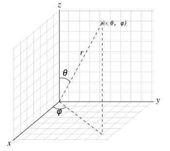
A diagram representing the three parameters of the spherical coordinate system. Note that these parameters are more commonly used in physics; in mathematics, the values of φ and θ are typically reversed.
The spherical coordinate system is a coordinate system for representing geometric figures in three dimensions using three coordinates, (ρ, φ, θ), where ρ represents the radial distance of a point from a fixed origin, φ represents the zenith angle from the positive z-axis and θ represents the azimuth angle from the positive x-axis. The geographic coordinate system is similar to the spherical coordinate system.
Coordinate system definition and notation

Coordinate surfaces in the Spherical coordinate system
The spherical coordinate system represents points as a tuple of three components. Typically in America, the components are notated as (ρ, φ, θ) for distance, zenith and azimuth, while elsewhere the notation is reversed for zenith and azimuth as (ρ, θ, φ). The former has the advantage of being most compatible with the notation for the two-dimensional polar coordinate system and the three-dimensional cylindrical coordinate system, while the latter has the broader acceptance geographically. The notation convention of the author of any work pertaining to spherical coordinates should always be checked before using the formulas and equations of that author. This article uses "American" notation.
The three coordinates (ρ, φ, θ) are defined as:
- 0 ≤ ρ is the distance from the origin to a given point P.
- 0 ≤ φ ≤ 180° is the angle between the positive z-axis and the line formed between the origin and P.
- 0 ≤ θ ≤ 360° is the angle between the positive x-axis and the line from the origin to the P projected onto the xy-plane.
φ is referred to as the zenith or colatitude, while θ is referred to as the azimuth.
According to this system, φ and θ lose significance when ρ = 0 and θ loses significance if sin(φ) = 0 (at φ = 0 and φ = 180°.
To plot a point from its spherical coordinates, go ρ units from the origin along the positive z-axis, rotate φ about the y-axis in the direction of the positive x-axis and rotate θ about the z-axis in the direction of the positive y-axis.
Coordinate system conversions
As the spherical coordinate system is only one of many three-dimensional coordinate systems, there exist equations for converting coordinates between the spherical coordinate system and others.
Cartesian coordinate system
The three spherical coordinates are converted to Cartesian coordinates by:


Conversely, Cartesian coordinates may be converted to spherical coordinates by:


The Jacobian matrix for transforming between sphericals and Cartesian coordinates is

Therefore, the volume element in spherical coordinates will be

Geographic coordinate system
The geographic coordinate system is an alternate version of the spherical coordinate system, used primarily in geography though also in mathematics and physics applications. In geography, ρ is usually dropped or replaced with a value representing elevation or altitude.
Latitude is the complement of the zenith or colatitude, and can be converted by:
- , and
- ,


though latitude is typically represented by φ as well. This represents a zenith angle originating from the xy-plane with a domain -90° ≤ φ ≤ 90°. The longitude is the azimuth angle shifted 180° from θ to give a domain of -180° ≤ θ ≤ 180°.
Cylindrical coordinate system
The cylindrical coordinate system is a three-dimensional extrusion of the polar coordinate system, with an h coordinate to describe a point's height above or below the xy-plane. The full coordinate tuple is (r, θ, h).
Spherical coordinates may be converted to cylindrical coordinates by:


Cylindrical coordinates may be converted to spherical coordinates by:


